The continous threat to human life from volcanic erruptions in the Andes has lead to a large amount of interest in developing strategies for predicting erruptions and monitoring active volcanoes ...
On a clear morning the volcanic mountains around Quito in Ecuador provide one of the most stunning sights that I have ever seen. The snow cap of Cotopaxi, the steep slopes of El Chimborazo, the hills around Pichincha and the distant Cayambe surround the Ecuadorian capital. These creations of nature form part of the Andes stretching down the northwest side of South America. However within the beauty of these volcanoes lies an enormous threat to the surrounding human populations. It was only twelve years ago that Nevada del Ruiz in Colombia errupted killing more that 23000 people, the second most deadly volcanic erruption in the last century.
The continous threat to human life from volcanic erruptions in the Andes has lead to a large amount of interest in developing strategies for predicting erruptions and monitoring active volcanoes. These strategies combine (a) satellite imaging analysis and (b) ground based measurements with studies of volcanic history,in particular when the volcano last errupted.
(a) Satellite and computer aided analysis
The Upper Atmosphere Research Satellite (UARS) developed by NASA has been
used to detect the levels of Sulpur Dioxide gas intoduced into the earth's
stratosphere from Mt. Lascar, Chile in April of 1993. This provides an
example of how satellite-based measurements have been used for examination
of changes after an erruption has occurred. Perhaps one of the greatest
contributions to volcanic erruption prediction in the Andes has come from
the US Geological Survey's Volcano Disaster Assistance Programme (VDAP) set
up precisely because of the cost to human life of the Nevada del Ruiz
erruption. The VDAP has provided a portable obsevatory for collecting
seizmological data on computer. More specifically, the computers used can
handle signals coming from as many as 128 seizmometers spread across a
given area of analysis. THE VDAP has also made use of a
satellite-dependent method for monitoring volcanoes. Referred to as the
Global Positioning System (GPS), receivers can be placed around a volcano.
Shifts in the land can therefore be monitored by satellite and transmitted
to the portable observatory.
(b) Ground based measurements
Perhaps one of the most useful methods for examining volcanic activity
involves measurements of inorganic ions in spring water around a
potentially active volcano. This is particularly true for Calcium,
Magnesium, Sodium and Sulphur. The ionic levels are then compared with
those observed in non-volcanic spring waters to assess whether a volcanic
erruption is imminent. This can be combined with siezmological data since
earthquakes around a volcano often preceed an erruption. In addition
volcanologists can directly measure ground shifts in terms of the distance
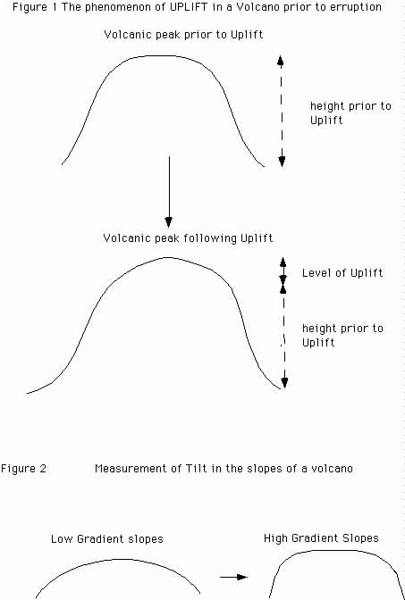
between two specific points in the volcanic crater. From such measurements
it is possible to determine the UPLIFT of the volcano defined as the rise
in the land caused by the internal pressure of the rising magma within the
volcano (see Figure 1). By comparing the values of Uplift (measured in
centimeters) with those of previous erruptions (if such data is recorded in
historical measurements) it is therefore possible for volcanologists to
assess the likelyhood of an erruption. Finally the volcanologist can
examine the TILT of the Volcanic slopes. As the magma rises into the
summit of the volcano, the gradient of the volcanic slopes is going to
increase (see Figure 2). Again by comparing results from previous
measurements, it is possible to use TILT values as a volcanic 'pressure
gauge' for assessing whether the volcano is about to errupt. Naturally the
TILT decreases following the erruption.