I don't have the meteorological data on hand to determine whether or not California has experienced windier-than-normal conditions so far this year. Since you are from the west coast, I will simply take your word for it, and try to explain how La Niþa may be responsible. If you want to obtain the data, I would suggest contacting the National Climatic Data Center.
As you mentioned, the west coast of the United States is nearly always under the influence of prevailing westerly winds, due to the earth's rotation. These winds are relatively stronger than winds in other parts of the country because they flow in off the ocean, where there is very little friction to slow them down.
La Niþa, like El Niþo, affects the position and intensity of jet streams. One may expect that for La Niþa to be responsible for higher winds in the San Francisco area, that the jet stream would be entering the west coast in the vicinity of central California. However, during La Niþa, the eastern Pacific jet stream typically enters the west coast near the U.S./Canada border.
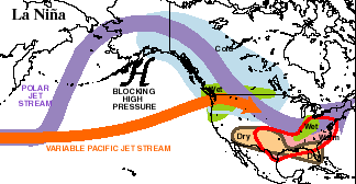
However, the position of upper-level jet streams has a direct influence on the position and movement of surface weather systems. Areas of low pressure are often steered by jet stream winds. This is why the jet stream is sometimes referred to as the 'storm track'.
Remember that air flows counter-clockwise around areas of low pressure. Therefore, as these areas of low pressure are steered into the Pacific Northwest, areas to the south (such as California) would feel strong winds with a westerly component.
To sum it up, it is quite possible that La Niþa has been responsible for the stronger-than-normal winds that you have been feeling.
For more information than you will probably want to read, check out these links...