| MadSci Network: Earth Sciences |
Hi...?:
The wavelength of hurricane waves will depend on lots of things – the wind speed, the time it has been blowing, and where in the hurricane they happen to be in the hurricane– all of the things that influence the size and wavelength of wind waves in general. I had a look around, and couldn't find any calculation of average wavelengths from hurricane waves, especially offshore (would you want to go out there measure them?!?).
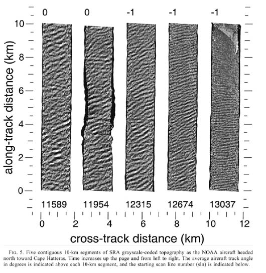
I did find one set of measurements though, published by some NASA/NOAA hurricane researchers: Hurricane Directional Wave Spectrum Spatial Variation at Landfall (that's a .pdf file, and it's almost 2 megs, so if you're on dialup it may take a long time to download). These are the "hurricane hunters" who fly heavily instrumented airplanes into hurricanes to try to figure out how they work (it's a living I guess, I think I'll stick to measuring the ocean from ships). One of the instruments on board is a scanning radar altimeter, an extremely accurate radar that can measure wave height. Here's a figure from that paper of SRA data (taken during hurricane Bonny):
The colour density is related to wave height (so it's kind of like a black
and white photograph), and the leftmost panel is most offshore, while the
rightmost panel is inshore. The wavelength is the distance between
like-shaded areas, and you can see that offshore the wavelength is
something like 500m to 1 km (and those waves were as much as 8 meters
high!), but they get considerably shorter closer to land.
A good way to get wavelength more accurately is to count the waves in the 10 km strip. For the strip on the left I count 34 waves in 10 km, meaning a wavelength of about 300m. On the right I count 45 waves in the first (bottom) 7 km, meaning a wavelength of about 160 m. Toward the top of this strip (where a corner of land is) the waves appear to be getting both shorter and smaller, and become difficult to discern.
So that ought to give you some idea of the wavelength of hurricane waves. If you're feeling keen, there is wave data available for download free of charge from the National Oceanographic Data Centre and you can download some data and see for yourself what kind of range there is in wavelength. One extremely good reference is Oceanography and Seamanship, by William and Richard Van Dorn. It's focussed toward the cruising sailor, but there is an excellent section on ocean waves, with special reference to storm waves (William Van Dorn is a physical oceanographer as well as an avid sailor).
I hope that helps,
Rob Campbell & John Christie, MAD Scientists
Try the links in the MadSci Library for more information on Earth Sciences.